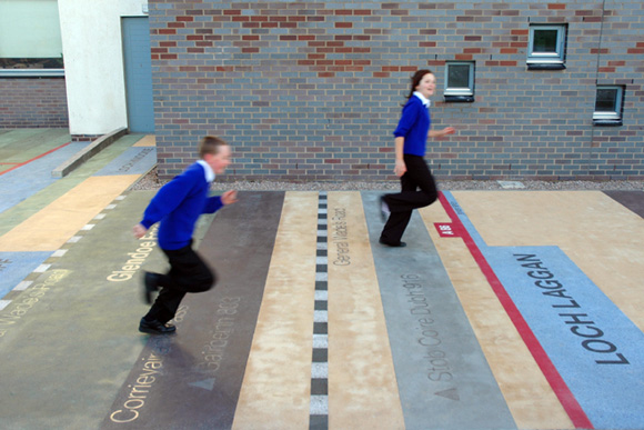
Painted maps of the country or state are a standard way to pretty-up the playground surface, but I wouldn’t call them elegant. But artist Gordon Young’s ‘Road to the Isles’ design for the Auchterarder school in Perthshire Scotland is sublime:
“A graphic cross section of the forests, lochs, rivers, glens, valleys, towns, roads and mountains, that can be plotted in a straight line from the school all the way to the Summer Isles in the North West of Scotland. The map is laid in front of the school building in coloured concretes, many with locally sourced sands, with inset granite and stainless steel text. Blocks of colour have been used as codes for geographical categories, benches named after islands off the Scottish West Coast have been arranged according to their geographical location and children enjoy sitting on Eigg and Muck and jumping from Harris to the Isle of Lewis. This ‘walk of art’ is also an educational tool; teachers are using the playground to stimulate discussion on ecology, geography, history and arts.”
This is a much more thoughtful, and elegant, approach to the playground surface map.
The post Elegant Playground Mapping, Perthshire Scotland, Gordon Young, 2004 appeared first on Playscapes.